16. juni 2025 nyhet
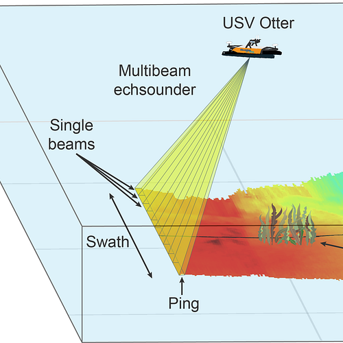
Akvaplan-niva is currently developing new methods to map kelp forests using sonars. These sonars are called multibeam echosounders and are traditionally used for bathymetry mapping, but here we record data from the water column in addition to the seafloor. This sonar system works by emitting multiple acoustic beams in a fan shape, covering a wide area called a swath (see figure below). The pulse of sound – a ping – emitted by the echosounder travels through the water, reflects off the seafloor or objects within the water column (for example a kelp), and is received by the echosounder. The multibeam echosounder measures the time it takes for the sound to return, along with the angle of each beam, to calculate the depth of the objects and create high resolution 3D maps of the area.

Here, we mounted the multibeam echosounder is mounted on a small Uncrewed Surface Vehicle (USV) – the Otter (Maritime Robotics). Furthermore, the Otter was equipped with a camera system to visually confirm what was observed with acoustics. Because of the small size of the Otter, we can map shallow areas that would not be accessible to a larger vessel. We deployed the Otter on June 2nd outside of the Framsenteret to collect multibeam echosounder data. Alongside the Otter, Pernilla Carlsson (NIVA) conducted a visual free-diving survey and manually counted kelps. Together, the sonar and count data will help us develop the software used for mapping kelp forests and estimate their density and biomass. This approach will allow us to monitor kelp recovery after urchin removal.

Video footage from the USV Otter showing kelp.

Pernilla Carlsson (NIVA) with a kelp during the visual free-diving survey (Photo credit: Pierre Priou)
The activity is part of the OceanGreen project led by Ava Ocean and partners are NIBIO, NIVA, Akvaplan-niva, Hofseth Biocare and Rissa Citizen Science.